What is the RasPiGNSS?
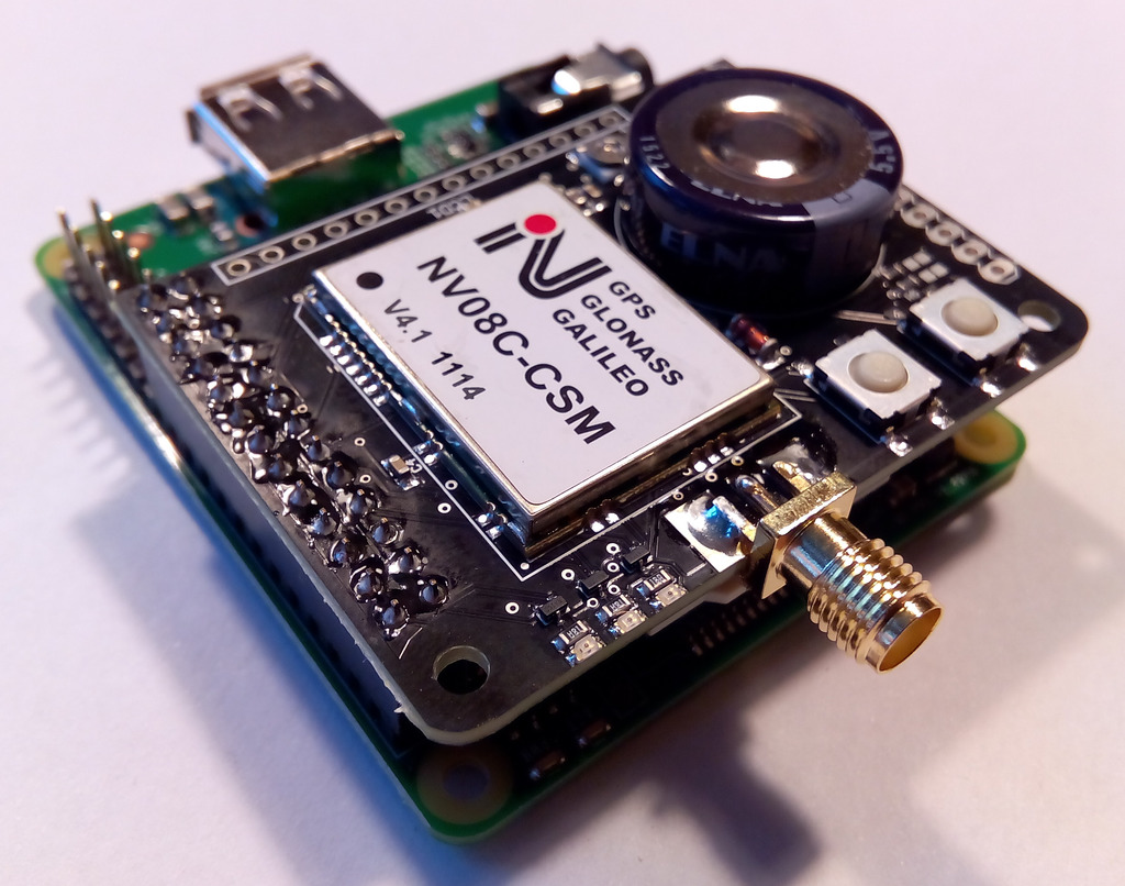
The RasPiGNSS “Aldebaran” is an expansion board or module (also known as a “HAT”) for the well-known Raspberry Pi mini computer.
It enables precise positioning tasks to be performed on the Raspberry Pi, which is due to its miniature size and modest power consumption ideally suited as a mobile GNSS recording and navigation device. Using this HAT with suitable software, the Raspberry Pi is capable of receiving and processing signals from the GPS (“Navstar”), GLONASS, and GALILEO navigation satellite systems.
Components of the RasPiGNSS “Aldebaran” board
The RasPiGNSS “Aldebaran” expansion board fits onto the Pi’s expansion connector (named P1), and employs the following components:
- An NV08C-CSM GNSS receiver module from NVS Technologies
- A female SMA socket for a GPS/GLONASS antenna with a male SMA plug
- A GoldCap for backup power to the NV08C’s memory
- Three low-power LEDs (red, yellow, green) for e.g. indicating the operating status
- two tactile momentary push-buttons
- Unpopulated pin header connectors for:
- a HD44780-compatible LCD display
- an UART interface to the second serial port of the NV08C-CSM GNSS chip
- an I2C interface for connecting all sorts of I2C device like IMUS, RTCs, flash EEPROMs, ADCs, etc.
- an SPI interface for connecting all sorts of SPI devices like RF communication modules, WLAN and bluetooth chips, etc.
Compatible with all known Raspberry Pi models
The RasPiGNSS expansion board is fully compatible with the Raspberry Pi models A, B, B+, Pi 2, Pi 3, Pi 4, and Pi Zero. Just make sure that on the Raspberry Pi A+, B+, Pi 2, Pi 3, Pi 4, and Pi Zero only the first 26 pins of the expansion port are used, which are pin-compatible to the models A and B. See the installation description for further information about installation on the RasPi model A+/B+.
GNSS Satellite raw data processing with RTKLIB
Due to the NV08C’s capability of raw GNSS data acquisition, both for GPS and GLONASS, it can be combined with Tomoji Takasu’s RTKLIB. Thanks to Michele Bavaro RTKLIB’s convbin is able to process NVS BINR raw data, thus delivering precise point positioning (PPP) solutions (i.e. without a reference station) with a 1-sigma 2D position standard deviation of as low as a few decimeters under ideal sky conditions, provided sufficient current and precise correction data (e.g. from NASA/CDDIS or IGS) is available for the recorded time period. Of course you can use two RasPis equipped with RasPiGNSS expansion boards and RTKLIB for a real-time kinematic (RTK) setup delivering centimeter-grade precision.
Use the “Add to cart” button below and proceed to checkout to order the RasPiGNSS. Please contact us when ordering quantities larger than 10 pieces.
What it is not
The RasPiGNSS is not your average plug-and-play GPS stick delivering an NMEA stream to your RasPi, although it could be used as such. If you simply want a GPS NMEA stream over serial or USB, buy one of the numerous GPS mouses or sticks available for connecting to a PC. They are a lot cheaper and will do their job in a Raspberry Pi as well. If you need however a fully flexible precise positioning device or better position fix capabilities due to GLONASS satellites (and all that on a Raspberry Pi!), then the RasPiGNSS is for you.
Please find more detailed information about the RasPiGNSS “Aldebaran” module within the following pages:


